EN

Translate:

New video! click to see "Jimmie Chow - Fiddletown's Colorful History.

  • Home
  • Amador
    • Jackson Butte Mountain
    • Red Mule Ranch
    • Peak Photos
    • Ancient Amador backroads
    • Hwy 49 Sights
    • Amador via satellite
  • Earth
    • Observations of Creation
    • The Mandelbrot Set
  • Vid+Pics+Drone
    • Amador via Drone
    • Videos and Time Lapse
    • Photographic Anomalies
    • Encounters
  • Us
    • PersistentOrganicMoss Art
    • About us
    • Contact Us
  • Best Evidence Yet
  • Ancient Amador Arcana
  • Symbols as Language
  • Earth:The Grand Art Folio
  • More
    • Home
    • Amador
      • Jackson Butte Mountain
      • Red Mule Ranch
      • Peak Photos
      • Ancient Amador backroads
      • Hwy 49 Sights
      • Amador via satellite
    • Earth
      • Observations of Creation
      • The Mandelbrot Set
    • Vid+Pics+Drone
      • Amador via Drone
      • Videos and Time Lapse
      • Photographic Anomalies
      • Encounters
    • Us
      • PersistentOrganicMoss Art
      • About us
      • Contact Us
    • Best Evidence Yet
    • Ancient Amador Arcana
    • Symbols as Language
    • Earth:The Grand Art Folio

EN

  • Home
  • Amador
    • Jackson Butte Mountain
    • Red Mule Ranch
    • Peak Photos
    • Ancient Amador backroads
    • Hwy 49 Sights
    • Amador via satellite
  • Earth
    • Observations of Creation
    • The Mandelbrot Set
  • Vid+Pics+Drone
    • Amador via Drone
    • Videos and Time Lapse
    • Photographic Anomalies
    • Encounters
  • Us
    • PersistentOrganicMoss Art
    • About us
    • Contact Us
  • Best Evidence Yet
  • Ancient Amador Arcana
  • Symbols as Language
  • Earth:The Grand Art Folio
Ancient Amador

Ancient California Gold

Ancient California GoldAncient California Gold

Amador via Satellite

Amador County parallel lines spaced 3 miles apart uniformly in actual topography

The Parallel Lines

Curiouser and curiouser....

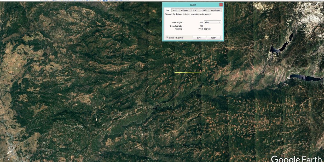
Amador County is more populated, naturally, in the lower elevations below the snow line. On the upper end of the county, towards Tahoe, there is a phenomena that satellite photographs show is shared with Californians from Oroville to Bakersfield. The lines are precisely 3 miles apart and are expressed in a variety of ways in the topography. This effect can be seen from 10 miles above the Earth to about 40 miles. One can zoom in on these lines and observe the fact that they actually do exist in the physical landscape and are NOT a product of mapping software or glitches. Above 40 miles, however, their subtlety becomes invisible.  

Other lines and grids

Of course the world famous Nazca Lines are known for their vast coverage of South American territories, but the phenomena of parallel lines, grids, and submerged features that are repeating patterns can be observed all over the Earth. What you need to locate these, is 10 spare minutes and access to a computer equipped with mapping software. Satellite imagery has made this exercise a walk in the park.

Home

Copyright © 2018-2023 Persistent Organic Moss

Produced by: Ancients of Hills dot com


Powered by unspeakable sources/unstoppable forces

Cookie Policy

This website uses cookies. By continuing to use this site, you accept our use of cookies.

DeclineAccept & Close